Flooding Maps

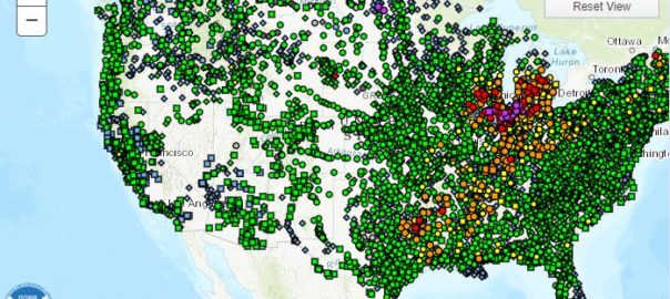
In today’s blog article, I just wanted to share a useful resource that the National Weather Service provides. It’s an interactive flooding maps tool that will allow you to see where in the United States is currently at risk of Major, Moderate, and minor flood events.
Using these flooding maps is a great way to assess your risk of a flood event damaging your home and property. Because these are updated regularly, you can see how the flooding risk will change throughout the year and in different areas of the country.
Additionally, if you’re curious about if your home is in or near a high risk flood zone, you can use the FEMA flooding maps tool at this link. This map has a lot of data and can let you know if your home is within the boundries of a high risk flood zone (varations marked by the letter “A”) or a low to moderate risk zone (known as X zones). If your home is in a special flood hazard area (SFHA) your lender will more than likely require that you have purchased flood insurance as condition of your mortgage.
To visit the FEMA National Flood Insurance Program’s mapping system, you can click here.
Once you’ve reached the FEMA GeoPlatform hub, select flooding, Once you’ve done this, click the link to the FEMA National Flood Hazard Official Layer as shown in the picture below. Finally, type your property’s address into the search bar in the upper right hand corner of the map and the system will allow you to see where your home’s location resides in conjunction with the flooding maps. This is a valuable tool to give you an idea if a home you’re looking to purchase may require flood insurance in order to fund your loan.

